

| Paddle
Smart - Weather Tips
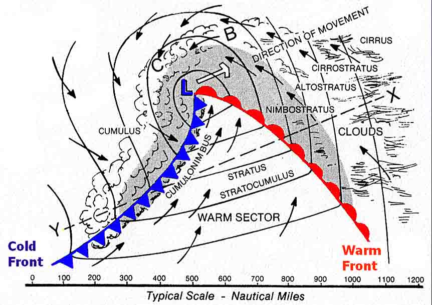
Paddle boating, whether canoeing or kayaking, is usually done close to a shoreline because there are more things to see, you are away from larger cruising boats and their waves, and if the wind should suddenly build or change direction, you are not far from refuge. Nevertheless, there are weather matters to consider when planning a cruising trip, and a basic understanding of weather systems and fronts will greatly add to your safety while afloat. Weather Systems: The weather does not just suddenly and instantaneously change unless a violent event such as a tornado or a microburst occurs. Usually there are well-defined changes in cloud type, wind direction, and barometric pressure that foretell an upcoming change in the weather. There is not too much a paddler can do to practically monitor barometric pressure while afloat; but, by observing the cloud types, cloud direction, and wind direction, you can effectively make a short-term weather forecast that will enhance your safety. Observing changes is the key. Weather systems generally fall into two categories: high pressure systems or low pressure systems. Low pressure systems are technically referred to as extratropical cyclones; don't confuse this term with tropical cyclones which are hurricanes. The wind circulates in a counterclockwise (ccw) direction around lows and clockwise (cw) around highs. Just knowing and applying the ccw or cw nature of these systems can help you make short-term forecasts. Most of the dangerous weather to boaters is associated with low pressure systems. Highs usually are associated with clear, but often windy, conditions. Low Pressure Systems and Wind Directions: Lows consist of a warm air mass, cold or cool air mass, warm front, and a cold front. In between the warm front, indicated with rounded bumps in the diagram below, and the cold front (triangular shapes), there is a region called the warm sector. If your location is south of the passing low pressure system, ahead of the warm front, the wind is generally coming from the southeast, hence is called a southeast (SE) wind. After the warm front passes, while in the warm sector, there is usually a south (S) or southwest (SW) wind. After the cold front passes, there is usually a west (W) or northwest (NW) wind. This sequence of wind changes, SE-S-SW-W-NW, is typical of lows. North of a low pressure system, the winds follow a distinctly different sequence, changing from easterly to northeast to north and finally ending up as northwest. Whether you are north or south of the low pressure center, you eventually end up with a northwest wind, but the sequence is different and the weather is decidedly different with each sequence. Learn to recognize the wind sequences, and you are on your way to making short-term forecasts. Cloud Types: Clouds are another indicator of changing weather. Again, the clouds change in orderly sequences just as the wind changes direction in an orderly sequence. By recognizing the clouds, their typical heights above the ground and their characteristics, you can enhance your ability to make short-term forecasts. High-altitude clouds are classified as being above 20,000 feet, middle clouds as being between 6,500 and 20,000 feet, and low clouds as below 6,500.
Fronts: As a warm front approaches, the clouds lower and thicken with steady rain beginning ahead of the front. Immediately preceding a cold front there is often thunder, lightning, and heavy showers; severe squalls are frequently associated with a cold front, making these fronts a serious safety concern for paddlers. At, or just prior to a cold front, the clouds give way from the generally overcast conditions of the warm sector to towering thunderheads, and eventually to broken clouds behind the front. By recognizing the clouds, you can forecast approaching fronts and the associated weather conditions, allowing you to reach safety in advance of severe conditions.
Fronts often travel in pairs associated with a Low Pressure Area. If you were standing at "X", the advancing warm front is gradual and associated with steady rain. The cold front that follows is more like a moving wall of more violent weather, often associated with squall line thunderstorms Restricted Visibility: Fog is a major reason that boaters encounter restricted visibility while afloat. Fog is produced when the air becomes saturated with moisture and the water vapor condenses. Radiation fog is common in the early mornings in low areas (such as river and stream valleys) and will burn off as the sun comes up. Often fog is associated with an advancing warm front. Another type of fog is referred to as advection fog. This fog is created when very warm, or hot, air interacts with cold water. The cold water chills the moist, warm air to the dew point and fog results. This type of fog can persist for days and requires a major change in the wind direction to improve the visibility.
Advection Fog is caused by warm moist air moving slowly across colder water. The colder water condenses the moisture in the air near it. The fog will stay until the wind pushes it away |
|
| Disclaimer|
Privacy
Statement | Trademarks
Page updated July 8, 2016 |
|


 Weather
Map
 Squall-line
Thunderstorm - Advancing Cold Front - BEWARE!


